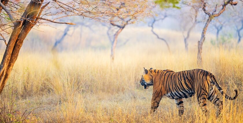
Mukundara Hills Tiger Reserve Landscape Guide
Mukundara Hills Tiger Reserve (MHTR), also written as Mukundra Hills Tiger Reserve, lies in the
south-eastern Rajasthan landscape around the Kota region. Its conservation value comes from
landscape diversity: hill ranges, dry deciduous forest, scrub, riverine belts, rocky slopes,
seasonal nalas, and reservoir systems that support both terrestrial and aquatic biodiversity.
Where MHTR sits in Rajasthan’s ecology
MHTR is best understood as a connected landscape rather than a single habitat block. The reserve
links upland hill terrain with river and wetland systems, creating multiple ecological niches in a
relatively compact geography.
- Hill system: the Mukundara range forms long rocky ridges, escarpments, and narrow valleys.
- Forest matrix: mostly dry deciduous and scrub-dominated vegetation with strong seasonal change.
- Water network: river stretches, backwaters, and seasonal drains shape wildlife movement and survival.
- Human edges: villages, roads, and land-use boundaries influence conflict and corridor use.
Habitat types that define Mukundara Hills Tiger Reserve
Search traffic around “Mukundara Hills Tiger Reserve” often focuses only on tigers. For real field
understanding, habitat structure matters just as much as species records.
Dry deciduous woodland
Seasonal canopy and leaf-fall cycles drive forage availability, visibility, and ground-layer dynamics.
Scrub and thorn forest
Critical for small mammals, reptiles, and birds that depend on dense low cover and edge transitions.
Grass-dominated patches
Important prey-supporting habitats that are often undervalued in management and public narratives.
Riparian belts
Tree-lined water edges that function as movement routes, nesting areas, and dry-season refuges.
Reservoir and wetland zones
High-use areas for waterbirds, turtles, fish, crocodilians, and mammals that rely on predictable water.
Rock faces and cliffs
Thermal and nesting microhabitats, especially relevant for raptors, scavengers, and rock specialists.
Hydrology and seasonal pattern
In MHTR, water availability controls wildlife distribution through the year. Seasonal water spread,
retreat, and persistence shape breeding, feeding, and movement patterns across taxa.
- Monsoon: nala flow and grass growth increase; amphibian and invertebrate activity rises sharply.
- Post-monsoon and winter: wetlands stabilize and waterbird diversity is usually highest.
- Summer: concentration around perennial water intensifies monitoring and conflict-management needs.
For conservation planning, repeat seasonal documentation of the same sites is more useful than one-time
“sighting” records.
Landscape monitoring priorities for MHTR
For anyone researching the Mukundara Hills Tiger Reserve landscape, these are the highest-value features
to track over time.
Habitat continuity
Track fragmentation from fencing, conversion pressure, or expanding built-use at reserve edges.
Riparian condition
Monitor bank stability, pollution indicators, and disturbance along river and reservoir margins.
Grassland quality
Record composition, invasive spread, and grazing pressure because prey-support depends on these patches.
Dry-season water security
Identify which natural and managed water points actually persist into late summer.
Disturbance hotspots
Map noise, traffic, extraction, or tourism concentration zones that repeatedly affect wildlife behavior.
Edge dynamics
Document transitions between reserve and non-reserve land to improve conflict prevention planning.
Mukundara map use: what to share and what not to share
Public map literacy helps awareness, but sensitive geospatial information should remain unpublished.
Use maps to explain broad habitat pattern, not vulnerable wildlife coordinates.
- Appropriate public sharing: landscape zones, major water systems, and broad management context.
- Do not publish: den sites, nest/roost points, exact breeding locations, or active sensitive use sites.
Responsible field behavior in Mukundara Hills Tiger Reserve
Good landscape documentation supports conservation only when field behavior stays low-impact.
- Keep distance: never approach wildlife for photos or videos.
- Stay on legal routes: avoid creating new tracks or entering restricted zones.
- Control noise: low disturbance improves both sightings and welfare.
- Do not geotag sensitive spots: protect vulnerable habitats from online exposure.
This page is updated as better source-backed information on Mukundara’s landscape becomes available.